North Ashanti Gold Project
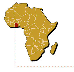
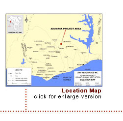
The North Ashanti Gold Project lies in the south-central part of Ghana, West Africa approximately 220 kilometers northwest by road from the capital city of Accra and 40 kilometers southeast by road from the country’s second largest city, Kumasi. (Location Map). The Asante Akyem North District capital town of Konongo is located immediately north of the concession area. Konongo is also the regional gold mining centre with several small open pit and historic underground mines. Gravel and dirt roads traverse throughout the North Ashanti Project area and a network of footpaths allows for easy access to a vast portion of the project
The North Ashanti Gold Project is strategically situated on the prolific Ashanti Trend and is surrounded by three gold mines. The Konongo Mine adjoins its northern border, the Anglo Gold Ashanti, ± 40 million ounce Obuasi Mine is located approximately 50 kilometers to the southwest and Newmont Akyem deposit (± 8 million oz ) permitted for 500,000 oz per year production is just 25 kilometers to the southeast.
Project Ownership/ Status
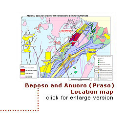
Ashanti Sankofa through it’s operating subsidiary, Ashanti Sankofa Limited, owns 100% of the North Ashanti Gold Project subject to a 10% carried interest by the Ghanaian Government. This project consisted of two Government granted prospecting licenses: the Beposo concession (33 sq km) and the Anuoro (Praso) concession (65 sq km). These contiguous licenses, cover approximately 98 square kilometers, and over 15 kilometres of identified gold anomalies between the Obuasi Mine and the Konongo Mine. The Beposo license was not renewed due to the governments implementation of a non-economic zone around Lake Botsumtwi. Ashanti Sankofa is negotiating with the Minerals Commission to reclaim this license.
Access
The sealed highway linking Ghana’s capital city, Accra, to its second city of Kumasi runs one kilometre north and parallel to the project’s northern boundary. Seven kilometres west of Konongo a sealed road runs to the south from the main Accra to Kumasi Highway. This minor road crosses the Accra to Kumasi railway and enters the Anuoro River Concession between the small towns of Bomfa and Adumasa.
The Ashanti Sankofa field camp is located on the outskirts of Adumasa. This sealed road continues south through Pemenase, located on the Beposo Concession, then back into the Anuoro River Concession and finally crosses the southern boundary of the project area just south of the town of Akyease. Access to all parts of the Beposo Concession and to the north-western portion and southern half of the Anuoro River Concession is possible from this Bomfa to Akyease sealed road.
Access to the northern and central portions of the Anuoro River Concession is possible by the well maintained dirt road which runs from the market place in Konongo southwards to the town of Praso. This road runs just inside the concession, parallel to the eastern boundary of the project area, and feeds a network of minor dirt roads in the area. Numerous unformed gravel roads link villages throughout the project. Access to more remote portions of the project is restricted to footpaths and cut-lines, and may become difficult during the peak of the monsoonal seasons (May to July and September to November).
Climate
The North Ashanti Gold Project lies 6º 30’ north of the equator and so is subject to tropical rainfall for most of the year. Annual rainfall varies from 1,200mm to 2,000mm. Climatic data for Kumasi, 35 kilometres to the northwest, gives a mean temperature of 26°C with an average annual rainfall of 1,465 mm. Two rainy seasons occur, one between May and July averages 160 mm per month and the other between September to October averages 186 mm per month. The driest period of the year is from January to March when the dry and dusty Hamattan wind blows southwards off the Sahara desert. During the dry season rainfall averages 54 mm per month.
Daily temperatures range from 22ºC to 30ºC, with humidity averaging 80 per cent.
Local Infastructure
The Beposo Main Zone can be reached using a periodically graded gravel road linking Pemenase to the communities lying on the southern shores of Lake Bosumtwi. Ashanti Sankofa has established bulldozed exploration tracks to provide access to all parts of the Beposo Main Zone resource area and to the adjacent Beposo South East Zone.
The Anuoro North Zone can be reached by well graded, dirt roads that run southwest from the Konongo suburb of Santreso, adjacent to the Kumasi highway.
The country’s main electrical power corridor extends along the Accra – Kumasi Highway and passes one kilometre north of the project area. A secondary line through to the town of Pemenase, located in the centre of the Beposo Concession, was activated in 2002. This line was extended to Adumasa during 2007.
Local labour is readily available with a nucleus of trained employees that have been involved with the project since 1989.
Ashanti Sankofa has a fully operational camp which supplies accommodation, meals, office facilities, a sampling yard, storage space and garage buildings for four wheel drive vehicles. The Ashanti Sankofa camp is supplied with water from its own dug well, is connected to the National Electricity Grid and has two diesel generators on site to provide back-up power when required.
Geology of the North Ashanti Gold Project
The Konongo area was mapped by the Ghana Geological Survey in 1937 and 1967. The 1967 work included a geological survey that defined broad areas of gold and arsenic mineralization. Survey results were published as Geological Survey, Bulletin No. 31, Moon and Mason.
A simplified geological map of the North Ashanti Project area is shown in Figure 2. The project lies along the western edge of the Ashanti belt where basin type sediments abut Birimian metavolcanics and metasediments. The area contains two distinct limbs of Birimian rocks which have been folded about a NE trending synclinal fold axis. A central core of Tarkwaian sediments is present which dies out to the south. The western limb of this syncline hosts the Konongo deposit to the NE. A linear granodiorite intrusion (the Santreso granodiorite) has been intruded parallel to the fold axis. Tarkwaian lithologies are also present in the east of the area and a further thin sliver of Birimian is present along the contact with the major Banso intrusion (Figure 3). Late NNW trending dolerite dykes traverse the licence areas.
Structurally the North Ashanti Project covers a segment of the Konongo-Axim Shear System, or Ashanti Shear. This shear zone occurs close to the belt margin and hosts a number of deposits and operating mines. The zone can be traced from north of the Konongo mine (1.4 million oz), through the Beposo project area to the Obuasi mine (41 million oz) (Figure 3). The shear continues towards the southwest adjacent to the western contact of the Ashanti belt and hosts the Bogosu mine (7 million oz) and Prestea mine (6 million oz).
Figure 3: Interpreted position of the ‘Ashanti shear’
An example of the aeromagnetic data covering the license area is shown below in Figure 4.
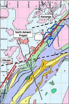
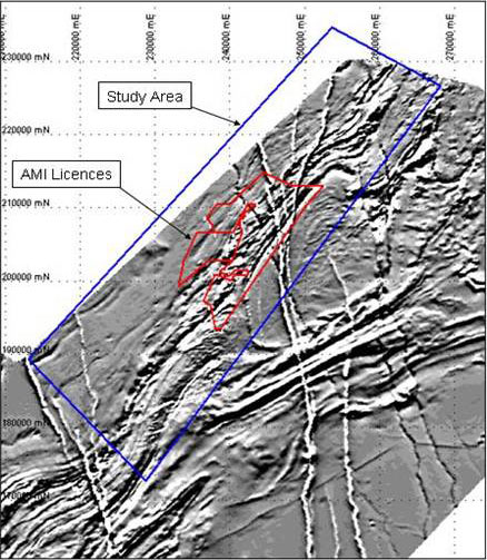
Figure 4: Aeromagnetic image covering the North Ashanti Project.
The structural interpretation undertaken by Dr. Colin Porter of SEMS Exploration in 2006 covering the Project and surrounding area is presented over leaf in Figure 5.
The area is dominated by a series of major through going NE trending shears which are interpreted as high angle reverse structures formed during regional NW-SE directed compression. These define the lithological pattern in the area with all units striking parallel to these structures. The main belt bounding structure occurs within the area and marks the contact between Lower and Upper Birimian. Several further NE structures are present including the same shear that hosts the Konongo deposit to the north. In addition the main syncline in the centre of the area is parallel to these features. The eastern portion of the licences includes the contact between Upper Birimian and Tarkwaian which occurs as a linear feature close to a major granites intrusion (Banso granite). The NNE structures are likely to represent the principal fluid conduits during the mineralization event.
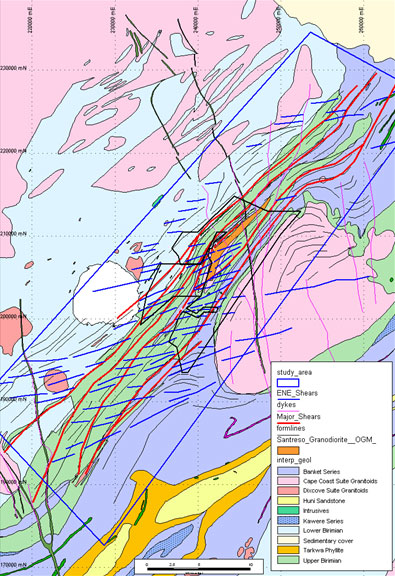
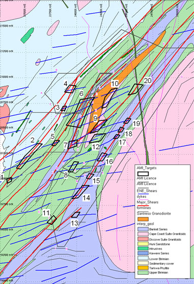
A second major structural trend is defined by a series of ENE trending cross faults. Structures of this orientation are important in the siting of several major deposits (e.g. Obuasi and Konongo, see Figure 5). ENE trending shears are notably more concentrated in the southern portion of the licence areas where they appear to show a spatial relationship with historical mineralization.
Using the intersection between NE and ENE structures as the primary target criterion a series of areas considered to be prospective were identified. These are shown in Figure 6 overleaf.
Beposo Mineralization
The Beposo Main Zone and South East Zone resource is defined by semi-continuous +50ppb gold in soil anomaly extending for three kilometres along the Ashanti Shear Zone. Gold in soil anomalism has been defined in the northern portion of the Beposo Concession which is likely to overly the same Ashanti Shear structure.
The Beposo resource area is made up of a western hanging-wall of unknown thickness of deformed phyllite and thin bedded greywacke, and an eastern footwall of thick bedded greywacke with minor sheared phyllite zones up to a few metres thick.
Boudinaged S0-parallel quartz veins and greywacke beds are a characteristic feature of the hanging wall zone. Numerous metre-scale folds are locally evident in both hanging-wall and footwall, and quartz veins in a variety of orientations are locally conspicuous. The mineralised zone dip varies considerably along strike from steep to relatively flat (~35 degree). A narrow sliver of felsic porphyry just to the west of the mineralised zone can be traced for much of the resource length.
Gold mineralisation is associated with a complex array of deformed quartz veins and arsenopyrite-silica-sericite-carbonate alteration. Field observations and experience from other Birimian deposits along the Ashanti Shear suggest there are three principal styles of gold mineralisation, as follows:
- Nuggety free gold within quartz veins;
- Gold associated with fine acicular arsenopyrite disseminated (typically <5 per cent) in silica-sericite-carbonate altered greywackes adjacent to mineralised quartz veins, and probably within some of the grey quartz veins;
- Free particulate gold within the oxide zone, derived from the weathering of the former two primary mineralisation types. Most quartz veins are small (<2m thick and <10m long), and can account for 20 per cent of the mineralised zones. More detailed mapping is required to understand the structural controls on gold mineralisation at Beposo but at least two quartz vein orientations have been identified, all appear to be gold-mineralised:
- S1-parallel quartz veins, grey, extensively boudinaged parallel to S1 and locally reduced to dislocated fragments within graphitic mylonite. These veins are particularly characteristic of the hanging-wall, but also occur in the footwall and parallel to S1 in the porphyry. Accessory carbonate and sericite are widely present.
Sub-vertical S1-perpendicular quartz lenses, occurring throughout the resource area. It has been observed that zones of higher grade within the mineralised zone correspond to a higher density of S1 perpendicular veinlets.
Anouro Mineralization
Exploration work on the Anuoro River Concession has concentrated upon a zone of anomalous gold-in-soil values that stretches from the northern concession boundary with the Konongo Mining Licence southwards to the Bomfa river. This discontinuous soil anomaly is over eight kilometres long and coincides with a granitic body that has intruded the Birimian / Tarkwaian contact.
Birimian metasediments mostly greywackes and some finer argillaceous units occur along the western margin of the granitic intrusion and Tarkwaian quartzites along the eastern margin.
Gold mineralisation appears to be associated with thin, gently dipping quartz veins and trace levels of disseminated pyrite within the granite. Most quartz veins dip to the east and strike roughly parallel to the regional structural fabric of the area – north eastwards. However, some veins have been observed to strike in a more east westerly orientation which parallels the current drill sections.
Three portions of this larger soil anomaly have been drilled: Anuoro North, Anuoro Central and Anuoro South. Figure 8 displays collar positions of holes drilled over the Central and South prospects.
The highest grade drilling results to date from this property occur within the Anuoro South Zone but the poor correlation of anomalous values between adjoining sections have prevented this data’s inclusion within the resource estimation. It is hoped further work aimed at understanding the structural controls on Anuoro mineralisation will allow a reinterpretation of this zone and subsequent inclusion in the resource category.
Results obtained from drilling over the Anuoro North zone have produced a more consistent ore body that stretches over ten drill sections or 900 metres of strike length.
The Anuoro North mineralisation is a direct continuation of the Santreso resource zone (+200,000 onces) as defined on the Konongo Mining Lease to the north.
The granitic unit is intensely weathered to about fifty metres depth which could probably allow ‘free dig’ open pit mining and heap leach processing. These characteristics enable the economic mining of lower ore grades than those in a conventional CIL processing circuit.
Mineral Resources Estimates
The current North Ashanti Gold Project mineral resource estimate, compiled by SEMS Exploration Services Ltd. in May 2008, is based on a combined total of 22,141 metres of reverse circulation percussion drilling (“RC”) and diamond core drilling. This breaks down to 196 RC holes for 17,606 metres, 16 RD holes (Reverse Circulation with a Diamond core tail) for 2,600 metres and 9 diamond core holes for 1,935 metres. Estimation employed the ordinary kriging approach to interpolation and data viewing, compositing, wire-framing, variogram calculation and modelling were performed using Micromine v. 11.0.1 software.

The cell sizes obtained for the Beposo Main Zone and South East Zone are listed in Table 18 and 19 which summarise the cell dimensions and block model extents for each zone respectively.
Table 18: Summary of Cell dimensions for Beposo Main Zone
| Zone | East | North | RL |
| Cell Dimensions | 7m | 7m | 2.5m |
| Block Origin (Centroid) | 681468 | 718272 | 87 |
| No. of Cells | 121 | 168 | 96 |
| Discretisation | 10 | 10 | 10 |
Table 19: Summary of Cell dimensions for Beposo South East Zone
| Zone | East | North | RL |
| Cell Dimensions | 5m | 4m | 2m |
| Block Origin (Centroid) | 681966 | 717790 | 147 |
| No. of Cells | 50 | 47 | 73 |
| Discretisation | 10 | 10 | 10 |
The block models obtained were flagged into separate domains, i.e. above and below the BOX.
Resource Classification
The search parameters used to decide the classification of a cell within the Block Model for both Beposo Main Zone and Beposo South East Zone as; Measured, Indicated or Inferred was determined by;
- Minimum number of samples found within the search neighbourhood.
For a Measured classification the parameter is set to a minimum of three sample points, for an Indicated classification this parameter is set to a minimum of one sample point.
- Distance using search radii
For a Measured classification and Indicated classification the search radii is equal to the long range. For Inferred, the search radius is increased until all cells in the Block Model are populated.
- The number of spatial sectors was set to 16 which ensures that the cell that is to be populated is taking from samples that are evenly spread around the cell and do not come from just one drill hole.
Figures 26 and 27 represent examples of cross sections through the Beposo Main Zone model. Figure 28 represents an example of a cross section through the Beposo South East Zone.
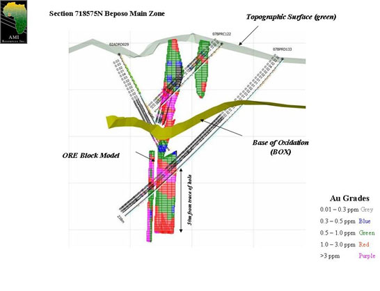
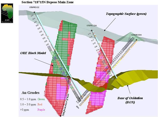
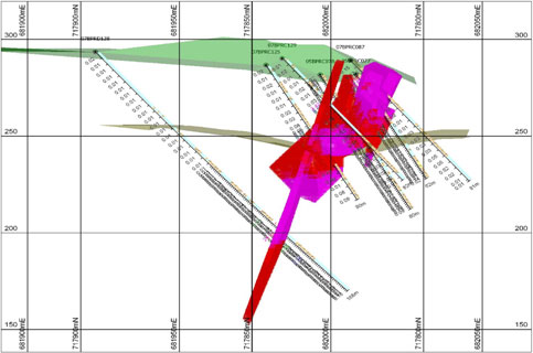
The Anuoro North Zone was classified using a polygonal method into an Indicated resource. Down dip resource block estimations were taken to 50 metres. Most drill sections are 100 metres apart.
Resource Statement
The North Ashanti Gold Project should be reported as listed in Table 20 below.
| Tonnes | Grade | Ounces | Sub Totals | Estimation | |||
| Beposo SE | Oxide | Measured | 83,261 | 2.81 | 8,243 | Ordinary Kriging | |
| Beposo SE | Oxide | Indicated | 90,514 | 5.63 | 17,976 | Ordinary Kriging | |
| Beposo SE | Fresh | Measured | 330,624 | 2.92 | 34,058 | 60,277 | Ordinary Kriging |
| Beposo Main | Oxide | Measured | 1,765,303 | 1.24 | 77,213 | Ordinary Kriging | |
| Beposo Main | Oxide | Indicated | 98,350 | 1.04 | 3,594 | Ordinary Kriging | |
| Beposo Main | Fresh | Measured | 1,296,266 | 1.53 | 69,893 | Ordinary Kriging | |
| Beposo Main | Fresh | Indicated | 507,772 | 1.06 | 18,958 | 169,658 | Ordinary Kriging |
| Beposo TOTAL | 4,172,090 | 1.56 | 229,935 | ||||
| Anuoro North | Oxide | Indicated | 565,432 | 0.92 | 18,349 | Polygonal | |
| Anuoro North | Fresh | Indicated | 2,121,896 | 1.06 | 79,337 | Polygonal | |
| Anuoro TOTAL | 2,687,328 | 1.03 | 97,686 | ||||
| North Ashanti Project | 6,859,418 | 1.35 | 327,621 |
Table 20: Summary of North Ashanti Gold Project resources


